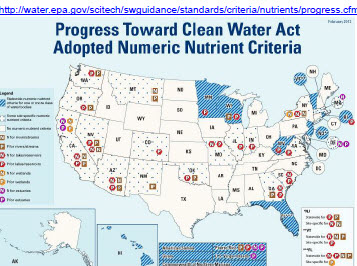
File:NNC Progress Map.jpg
From Coastal Sarasota Watersheds Wiki
No higher resolution available.
NNC_Progress_Map.jpg (357 × 266 pixels, file size: 47 KB, MIME type: image/jpeg)
map showing location of NNC adoption in US
File history
Click on a date/time to view the file as it appeared at that time.
| Date/Time | Thumbnail | Dimensions | User | Comment | |
|---|---|---|---|---|---|
| current | 17:00, 14 September 2012 | | 357×266 (47 KB) | Jan Allyn (Talk | contribs) | (map showing location of NNC adoption in US) |
- Edit this file using an external application (See the setup instructions for more information)
File links
The following page links to this file:
